A state-of-the-art unmanned aerial vehicle (UAV) is set to help the Moors for the Future Partnership monitor and analyse the impact of conservation works across vast, open moorlands.
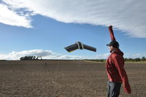
Members of the science team had their first official flight with the UAV at the end of last month. The specialist equipment is set to capture earth observation data to monitor the impact of blanket bog conservation works at a landscape scale, rather than the traditional site scale.
The data collected will be analysed to monitor land cover change across the Peak District and South Pennines over the next few years, including increases in the extent of sphagnum moss and reductions in bare peat.
The contract for the innovative project was awarded to QuestUAV and Nottingham Trent University after a rigorous tender process. The specialist vehicle is capable of capturing colour and multispectral imagery at the same time, and has the ability to house a thermal camera too.
UAVs are used for a number of reasons including recreational and military; around two million recreational UAVs were sold around the world last year aimed at consumers, and military UAVs account for the vast majority (nearly 90%) of worldwide spending on the equipment. There are also many other uses for UAVs including mapping and GIS, surveying, inspection, construction, mining, agriculture, security, public safety, science and research, and maybe even delivery sometime soon!
So with all these people using UAVs it is important that they are used responsibly. The use of UAVs is therefore subject to safety rules, which are underpinned by UK law. Team members must guarantee that they have all of the correct permissions in place before they can fly the UAV, including from the Civil Aviation Authority (CAA), Natural England, individual landowners and tenants. They also have to follow the ‘Drone Code,’ launched by the CAA last year, ensuring they abide by instructions including staying below 400ft (120m) and keeping the right distance from people and property.
The team has also established a UAV working group to develop a code of best practice in the use of UAVs for peatland monitoring and conservation. The group met initially in June and has representatives from Lancashire and Manchester Fire and Rescue Services; Nottingham Trent University; Manchester Metropolitan University; The University of Manchester; National Trust; RSPB; Yorkshire Peat Partnership and Yorkshire Water.
Senior research and monitoring officer, Tia Crouch, has been at the forefront of the UAV works. She said: “We’re particularly interested in monitoring blanket bogs that have become dominated by single species, such as cotton grass, purple moor grass and heather, as well as areas that were previously dominated by bare peat”.
“The team is very excited to head out to a series of experimental catchments – what we’re calling field laboratories – across the Peak District and South Pennines, to take flight with the UAV. Capturing this vital data will help us to showcase the positive impact that conservation works are having on our iconic moorland habitats.”
Up, up and away, the UAV takes flight - watch on social media.