The Land Cover Map we’ve created to help monitor our on-going conservation works is featured on the Ordnance Survey (OS) website.
As well as identifying areas that have become dominated by single species, the Land Cover Map will aid the planning of land management and restoration works, and provide a baseline for monitoring the delivery, impacts and outcomes of our MoorLIFE 2020 project.
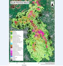
As the South Pennine Moors Special Area of Conservation is so huge (covering around 650 km² of northern England), satellite and aerial imagery were combined with field survey data before being analysed to produce the map (with the help of consultants Environment Systems Limited).
OS data was used including OS MasterMap layers which could mask out features such as water and manmade/ urban surfaces before the mapping started.
This was pivotal to the project as using satellite imagery alone would not have picked up roads, rivers and houses obscured by trees and other factors.
OS MasterMap Topography data provided detailed views of the landscape, while surveyors and volunteers used OS 1:25 000 Scale Colour Raster maps to go out and directly observe more than 230 areas for clarification or ‘ground truthing’ before data was then updated to the geographic information system (GIS) and included on the final land classification maps.
Read and download the case study in full.