Members of our team are set to be flying high as they get their unmanned aerial vehicle (UAV) surveys underway this week, to monitor the impacts of our conservation works on upland blanket bogs.
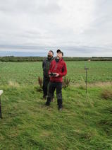
The team will be working alongside Nottingham Trent University and Yorkshire Peat Partnership to fly the UAV at various locations across the Peak District National Park and South Pennines Special Area of Conservation until 31st October 2018.
UAVs are used in a number of work areas including recreation, military, construction, mining, security and agriculture. All UAV work is subject to legally-binding safety rules, so the team has to follow a strict procedure including training on its use and gaining permissions to fly.
Our UAV will collect data to monitor land cover change across the vast, open landscape over the next few years, including increases in the extent of sphagnum moss and reductions in bare peat. This vital activity helps us provide evidence of the benefit of conservation works.
If you’re out and about enjoying the boggy moors in the coming months, you might see the UAV in flight. The specialist equipment does contain a camera; therefore images of people may be inadvertently captured from time to time.
Please look out for our ‘UAV at work’ signs on nearby footpaths, letting you know our survey locations on the day. Our volunteer field marshals will also be able to give further details about the timings of the surveys.
If you’d prefer not to be filmed, you can chat to members of the team on site and decide to wait nearby for the UAV to pass. If you have any concerns about imagery collected by the UAV, please get in touch via: moors@peakdistrict.gov.uk.
A privacy notice is available on the Peak District National Park Authority website.